Drew What's the Frequency Kenneth Now with X band!
Show transcript [en]
Um, Elband's unfortunately probably not going anywhere. Um, beyond the meteor constellation satellites that are going to be launched by Rosscosmos, um, ESA and Noah both have no plans to put LBN transponders on any of their new satellites moving forward. So, um, whilst this is fun, um, it it will be timelmited. Um, and you can 100% count on ESA to de-orbit uh or decommission a METOP satellite while it's still fully working. Um, because that's exactly what they did with METUP. Um, so moving on from there, uh, I want to give a quick update on Elband uh, geostationary stuff. So um this is actually a slide from my last talk but I liked it because uh up on the top left it gives you a
perspective of the earth and all the various low earth orbit weather satellites from a distance perspective and then it shows you how far away geostationary orbit is in comparison. Um, so basically geo stationary is what it says on the tin. From our perspective on the planet, these satellites are stationary in a single point in the sky. Um, in actuality that's not actually the case. Often they perturb around a point in a figure 8 perspective. Um, it depends on how much fuel they have, how much station keeping they can do, etc., etc. Um, some geostationary satellites are better than others. Some satellites you cannot point to, leave your dish in the same spot and expect 12 hours later
to have sync because it will have moved that much even though it's in geostationary. So, um, geo's good because you can just leave the dish set up. Obviously, once you point and get a good signal to noise ratio, you don't have to track anything. Um the downside of geostationary is because things are further you don't have as much signal strength and so therefore your margin is lower in terms of getting locked. Um but what I would say is here in Australia uh especially here in Western Australia um I feel like we're kind of in the Goldilock zone for geostationary if I'm going to be honest with you. Um, so there are currently two Russian geostationary weather satellites uh
within view of us, Electrol and Electrol. Um, there's also Fingyong 2G and 2H. Those are Chinese geostationary weather satellites and an older generation. There's also Fingyong 4A and 4B. They're also Chinese geostationary satellites, but a newer generation. Um, we have what's now known as EWSG2. Noah basically takes old GO satellites that they use over the continental United States. They basically run GOE's east and goes west and then they have a a hot spare in orbit as well in case one of them fails. Every time they send up a new satellite, they end up having a second spare. So what Noah has done is that basically they hand that satellite over to the United States Space Force
and then Space Force pushes that thing over um basically to the sort of uh over the Middle East and North Africa and then it becomes a United States Space Force geostationary weather satellite. It's still the same ghost satellite. It's still unencrypted, still running the same services um that it did historically. It's just now it's owned by the United States Space Forces and is a military asset. Um beyond uh EWSG2, there's also uh Geocat 2A or GK2A. That's a South Korean geostationary weather satellite. Um and then finally, there's Himoari 9, which is Japanese. Um, you would probably recognize it uh because all of the bomb imagery that the Bureau of Meteorology uses from geostationary comes from Hima
9. So if you go to their website and look at like the current satellite photo of Australia, that's where that data is coming from. Um, so yeah, we we're very lucky out here in terms of the number of geostationary targets that we have and the amount of data that we can get from them. So from my talk in 2023 to now um a couple things have changed with Electro L. Um firstly on the left hand side that's an Electro L3 image. In 2023 it never did a fully illuminated full disc image. For some reason Rosscosmos turned this on earlier this year. Um I don't know why. Nobody knows why in the hobby. I can tell you now that it's also
off. So, they're now no longer doing that time slot on a daily basis. Um, but yeah, it's it's a bit weird. It was one of my biggest gripes about the satellite. It only does images every 3 hours. Um, but it would never historically do the fully illuminated uh full disc image. Um, now it kind of does. Um, and then on the right, this is Electro L4. Um, this is the newest Electro L satellite that's been deployed by Russ Cosmos. As you can tell, it's further east from Electro L3. Um, when New Zealand's not covered in cloud, you can actually see New Zealand pretty well. Um, but yeah, that's an interesting satellite as well, just because it's it's nice to have options.
Um, Electro L3 is going to be replaced by L5 within well, it was meant to already happen this month. Um, that launch has not occurred. Rosscosmos will get L5 up. Uh when they do, they will drift that over to replace L3 and then they're going to take L3 and move it over to replace Electrol L2, which we can't see. That basically sits over uh Western Europe. Um and it's beyond its Xband service. It's basically completely broken. So, I can tell you right now all the uh European hobbyists are are very excited about the opportunity to start receiving that weather satellite. Um, moving forward from here, I want to quickly show you a few photos of
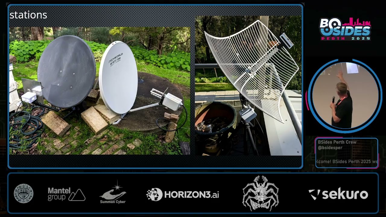
stations that I've got. Um, I'm not running all these anymore, but at the time I was. On the left, that was a Geocat 2A uh low rate information transmission station. um that satellite that's the South Korean one I mentioned earlier. Every 10 minutes it will send uh a single infrared IR 105 band image down. Um it's not great because it's infrared only, but because it transmits every 10 minutes, you can build very nice looking animations out of the imagery. Um in the middle, the the sort of cream color dish, that's my electro L3 station. um that's still running now. I've had that up since April of 2022. So I've collected a fair amount of electroheld um geostationary imagery
now. Um enough to know that yeah that satellite is interesting because of its lack of reliability in my opinion. It things are constantly changing with that thing and often not for the better. Um on the right, this is a new basically uh go dish setup that I brought back from the states years ago. Um the two dishes on the left, you can see that I've got helical antennas on the front of them, well helical feeds, I should say. Um on the right, this dish is a linear feed. So it's designed, it's optimized for linear instead of helical transmissions. Um and because of that those are very suitable for the fing 2 series satellites of which there are two still available.
So moving on from here um after the bides 2023 uh conference um that October uh was basically when EWSG1 which was originally GO 13 was being replaced by
in elevation to our west. Um, still plenty enough altitude for you to receive it with a a good setup. Um, unfortunately because I live up in the Perth Hills and I'm surrounded by trees, um, I I can't get a 20 degree elevation lock on any satellite. Basically, about 30° is uh about the lowest I can receive from my location. Um, so yeah, I can no longer receive this. Uh, that being said, uh, other people with a clear view to the west would be able to receive this uh, fairly easily. Um, it's a linear transmission. Um, is similar to what I was speaking to earlier. So, that dish setup that I have there, that's a 1.8 uh meter prime dish.
Um, because it's a prime, I threw a canana in front of it. Um, because it's an LBN Cantana, the dimensions are quite big. Um, and yeah, it was pretty weird throwing that together because I finally realized my best bet was to go down to the local IG and buy two of the very large Milo tins. Um, basically I took one Milo 10, cut the bottom off the second one, wedged that one onto the first one to get it the proper length, and then threw uh an SMA flange as they're called, which is basically a SMA connector with a metal rod attached to it. cut that to length and that was my feed. So you you might
look at this and think, "Oh, that's that's incredibly technical and it's like no, it it's literally two Milo 10 slammed together with an AliExpress SMA that costs maybe a dollar." Um, and yeah, this is what I was getting off of it. Uh, bit of a funny story. We don't drink Milo in our house. Um, but my son has a friend who does. So yeah, we had the really awkward situation where we showed up to school one morning and handed over two Ziploc bags full of brown powder to um to another parent like while we were dropping the kids off, you know. And uh yeah, that was always in hindsight, I thought maybe maybe I shouldn't have done that, you
know, like maybe maybe that wasn't the best of ideas, but hey, you know, like if I started telling people why I was doing it, I think they'd be even more concerned. Okay. So, um, moving on from here, once I started investigating EWSG2, um, I pretty quickly realized that, okay, well, this is a geostationary satellite operated by the US Space Force. They they've got to have a ground station for this thing, but we're on the other side of the world from America. Where are they going to put this ground station? Um, and the obvious answer is Western Australia. Um so up north from here um Swedish Space Corporation operates what's known as the Western Australian Space Center. Um SSC is a uh
private corporation that basically operates um ground stations throughout the world for commercial services and governments to basically have satellite uplink and down link capability. Um it it kind of blew me away. I reached out to them out of nowhere and said, "Hey, I'm a weird dude in the Perth Hills receiving satellite imagery. You all want to catch up?" And uh pretty quickly go, "Oh yeah, the the the whole Noah like ground station teams coming out in late October to commission the the new or the new satellite uh at the ground station and why don't you come up and meet them?" And I said, "Yeah, that would be really cool." Um, so yeah, I got to drive about 5 hours up north. Uh,
you can see up there's Geraldton and then inland quite a bit is where the space uh um the space center is. Um, there's a lot of stuff up here in general. Um, there's also a a listening station up there. Um, one of the guys that I met that was working at SSC had actually just resigned because he was going to the listening station to get a job. He had just accepted a job there and it was starting in 3 weeks. That was a fun conversation. Um, yeah, but it's it's it's quite a large facility um with multiple dishes uh across across the site. Um, it also does some search and rescue work uh which most of that stuff bounces off satellite
as well. Um but yeah, very interesting to go up there. So, um while I was there, uh on the left, that's the Noah US Space Force dishes. Um these actually came from Wallops Island in Virginia where Noah has their their ground station for uh the if I'm not mistaken, the East Coast uh goes satellite goes east. Um they fully disassembled these satellites, shipped them to Western Australia, and then rebuilt them on the spot. Um when I when when I was trying to organize to go up and visit, it was an interesting conversation because obviously this is a United States Space Force asset. Um that's US military. Uh I wasn't sure what, if anything, I I would
be able to see. Um, I drove up on the day when they told me to come up and when I got up there basically I was informed that that morning like word had come through from Washington that like they could show me around. Up until then they didn't know which was pretty interesting. So, but honestly I didn't care anyway because there's more to the site than just the fenced off Noah US Space Force ground station. Um, but it was very good because I ended up being able to go into the shelters, which are the little buildings you can see there. Um, no photography in any of the shelters, but that's basically where all the the hardware, all the ground station
hardware uh runs that basically receives and transmits uh to the satellite. Um, very interesting time. Very nice to meet the Noah team. They were lovely people. Um, I' I'd like to go back to the States sometime in the future and drop into Wallops and hopefully catch up with them again if I get the opportunity. Um, while I was up there as well, in the middle of the this image, you can see one dish pointing straight up. That's actually a uh Space X owned asset. Um, SpaceX uses that dish for Crew Dragon video downlink facilities. So basically anytime SpaceX launch launches uh a Dragon capsule with people in it, anytime it's over the Indian Ocean uh
region, all the video downlink from that uh capsule is received by this thing. You can't see it because I stupidly actually you kind of can just see it. That's my car in the way. But just above the windcreen you can see the Starlink uh dishy terminal. Um that's how they're back hauling because as you can imagine the Telstra network connectivity up there is worse than garbage. Um so like yeah they're just like no we'll just throw literally they they just got the the the cable running from out of that little shelter there on on the ground dish sits out there and yeah that's how they back hole all the video back to the United States over the Starlink network.
Um, on the far right you've got a Jaxa uh owned dish. If I'm not mistaken, this is both Cband and Xband. Uh, Jaxa uses this for launch telemetry. They use it for satellite station keeping. Um, when when I was there, there was actually a JAXA engineer there working in the shelter while while I was being shown around and it was awesome. like shoes outside the shelter door, you know, just like I I I wish I could have gone in because I reckon it would have been the cleanest and best shelter um in the entire place. But yeah, uh unfortunately because they were actually doing work at the time, um the SSC people said, "No, sorry, we can't go in there." Um I I'm
hoping to go back up and visit again um in the near future, maybe in the next few months. I I have reached out again um and I've touched base with them again, fingers crossed. Um, ISRO, which is the Indian Space Agency, also utilized this site. Um, that was really interesting. Like in the main building there, they have some uh HP thin clients that we could probably go down to Ross' auction and buy like 30 bucks a pop, as many as we want. That's what they're running their their their like tracking uh software on top of. Like I I love ISRO. like they they run on a shoestring budget and they do amazing things in space with it. Um
so moving forward from there, I want to jump over here um to a little bit of SPAM weirdness as I mentioned earlier. So um there's there's a guy online called Scott Tilly. Uh he he's Canadian. Um I'm pretty sure he's up in British Columbia. his his sort of claim to fame was Scott found a a NASA satellite um roughly a decade after they lost it um and it never worked for them and he found it found it transmitting sent him an email uh on the weekend saying hey guys I think I found your satellite you know and and on Monday like his inbox just got swarmed with messages from researchers and you know uh uh other
people who were basically just over the moon because the satellite was functional. Um they were able to get data off of it and everybody was just like, "Oh, you know, we thought this was dead years ago and like, yeah, you just greatest Christmas present of all, right?" You know, so um in December 2023, uh uh Scott reached out to me. Um it's not that I I'm anything special or or am even very good at these things. I I I have dishes, I have hardware, and I can listen on multiple bands. So, that combined with the fact that I'm out here in Western Australia and there's not very many other people out here and we're pretty far away from everyone
else. Um it it makes it a useful place to look for things that obviously you can't see from North America because there's a planet in the way. Um, so Scott reached out to me in December of 2023 and said, "Oh, you know, the Chinese are launching a space plane." And like basically what we were trying to do is find emissions from either the space plane or the objects that were deployed alongside of it. So we could basically get an idea of the orbital parameters with which that satellite was uh orbiting. Um there's a tool in in the hobby uh called STRF which is basically a Python software suite where you can take a bassband recording combine that
with accurate time and location via GPS and compare that to TLE's from NORAD space track of all the objects that are currently orbiting the planet and actually fit the object uh to a known well fit the transmission to a known object. So, it allows you to sort of map who's transmitting what above you when they transmit it. So, um sitting out in the backyard, you know, with my 1.2 meter with an Sband, uh uh helix on it looking for, um objects from the space plane. So, this is, you know, an image of SAT dump over here. I had g predict up and you can see that I basically imported all of the the twoline elements
for the space plane objects that we were looking looking at to see what transmissions uh they were they were potentially doing um to try to figure out basically what what are they doing with the space plane and all these objects um about yeah quite quite long into the pass um as you can see here so it was starting to to get quite low it was just above 30 degrees elevation Um, I got this stoning signal, you know, and I'm just like, uh, wow. Like that just turned on out of nowhere and like that's really big and quite powerful and it's on the frequency that we're looking for. Oh, I found like either the Chinese space plane or one of their objects. So,
I sent the basement recording to Scott Tilly in in Canada. Um, Scott used the STRF tools to try to fit it. Um, come to find out, YUbuntu NTP isn't very good is the long and the short of it. At the time I was running Yuntu on my laptop, um, because it was a fairly new laptop. Um, and yeah, uh, Scott tried to massage the data as much as he could and he's like, "Oh, I think I've got a reasonable fit." And it looks like that was object D. So, um, Scott starts posting about this on Twitter. Um, other space news websites start picking up on it. I had to send a weird email to my mother saying, "Hey,
like, uh, there's screenshots from my Twitter, like on the internet now, like in the news, just in case you're aware." And come to find out my brother-in-law had already told her, which was very confusing. But yeah, um, moving on. uh we basically realized that it it wasn't the Chinese space plane or or any of the uh Chinese space plane companion objects. Um a after uh a bit more work on on time and then me starting to do recordings on a Debian laptop in instead of the YUbuntu one I was using at the time. Um we started to quickly realize that um this transmission was from Yao GAN 30X. Um Yao GAN is the name of the Chinese
spy satellite networks. Um there are multiple. So there's 30 31 I think 34 35 36 38 39. They're into the 40s now. Um there are a lot of these birds up. Um, they're all transmitting over Australia. Um, the interesting thing about this that, uh, put Scott Tilly a bit on the back foot and and the reason why we sort of got confused initially is none of this happens over North America. None of these satellites transmit on these frequencies above Canada ever. But here in Australia all the time from horizon to horizon these things are are loud ass. Um so yeah it was a pretty interesting sort of thing. Um as you can see from here Scott went back
redid some STRF analysis identified it actually as Yaoan 30X. I started doing more uh recordings after that just to do more STRF matching just to confirm um 100% it's Chinese sat satellite uh spy networks um and yeah it's it's all uh encrypted um up in the top left you can see the post where basically we provided the the bassband recording to uh Allen who's in his 20s he's the lead developer of sat dump he's uh in France Um, the best way I I like to describe it is he sort of looks at satellite pictures, crosses his eyes like it's one of those uh 3D images and he can sort of pull out the imagery out of it that the he he can
basically decode stuff off the fly almost. It's uh a rare talent. Um, but yeah, he built a decoder. Uh, we had a look. All the data is encrypted. And that's where I'm going to leave it because I don't really know what else to tell you other than yeah, they they're doing this stuff above us, but over North America, they're not. All right. Now, we're going to move over to Xband. Um, this is my current Xband setup that's currently still set up in my backyard. Well, in my driveway. So, um, I'm going to quickly take you through this. That's a 1.2 meter offset dish. In front of it, I've got what's known as a wave guide. That's what takes uh the
transmissions that get reflected off the dish. You might look at that wave guide and think, "Oh gosh, like what what is that?" And it's a it's a 28 mm to 42mm copper pipe reducer for plumbing and uh 26 mm ID 28 mm OD copper pipe with an endcap on the back of it with a single SMA flange cut to length at 7.5 millimeters. It is not rocket surgery this stuff at all. Um yeah, it's it's quite simple in theory. Um, it's basically a cantana. So, above that, you can kind of see a box. That's what this is. This is a different model, though. This is a low-noise amplifier for Xband. Um, I got this from Down East
Microwave. They're in Florida, uh, in the United States. Um, initially, and I'll show this to you in the in a couple of slides, initially, I was using a single LNA. um I wasn't able to get strong enough signal to noise ratio. Um about six months into Xband receiving I started chaining LNAS. Um and that's when everything went good. So yeah um I now run two LNAS. You always run the first stage with the lowest noise floor. Um how RF chains work basically the first device that that sets the noise floor sets it for the entire chain. So, you use a low noise or a very low noise amplifier as your first stage. Second stage, you can basically
put a microwave amp there. Um, it doesn't need to have a low noise floor because that's already been set by your first component. And then that basically boosts up the signal. So, as you can see, basically I've got one sticking up and then it goes to a second one, which is this little guy right here. I picked this up off of eBay a while back. Ah, should have unwrapped that beforehand. This is uh Narda Matech LNA um used off eBay. All all of this componentry is going to run you at least $und00 US used um plus shipping. Um a a new LNA from the states from from Demi is going to run you 150 to close to
$200 US excluding shipping. Um this is the first problem with Xband. Um, it's not cheap. It there's no sort of like wide hobbyist market to lower costs uh uh of sale. So, yeah, it's a bit of a disappointment, but what are you going to do? Regardless, moving on, once you get through the low-noise amplifier stages, you then need a down converter. Uh, basically all the softwaredefined radios that we use, um, unless you're going to buy one that costs what a car would cost, um, they're going to max out at 6 gigahertz. All of the Xband frequencies sit basically between 77 megahertz or 7.7 GHz up to roughly 8.4 GHz. So, I need a device that basically
takes Xband frequencies and then downshifts it to a lower frequency that my SDR can then listen to. So the L of this down converter, which is hobbyist made from a guy named Arvd, is uh 7,000. So effectively, whatever I'm listening to at at any given time, it the frequency gets down shifted 7,000 and that's what I listen to. So first, why do Xband? Um and the answer is uh so many channels is so much higher resolution and so many more instruments. Um these are all the current generation weather satellites uh from their respective countries. So this is uh a mercy 2 um the medium resolution spectral imager. This is on the Fingong 3 Chinese satellites. As you can see
there's a ton of bands and there's very good resolution. Basically the visible bands that you can see are 250 meter per pixel. Most of the infrared bands are 1 kilmter per pixel. So um moving forward started out in February 2024 doing Xband immediately hit some problems. Um top left that's an image from Aqua which is a United States Xband weather satellite. Aqua has no error correction. It has no no fck uh enabled on the transmission. So once you drop below 10B decibb in signal to noise ratio, you start getting drops from the satellite. So as you can see, multiple lines across that were where I actually dropped in SNR and couldn't maintain lock. On the bottom
right, this is an image from Fingong 3D. Um, this was sampled at at 50 million samples or sorry, 40 45 million samples per second, which is quite grunty, let's be honest here. Um, once you start sampling at that rate, you start realizing that SSD and NVME drives have buffers that fill and then start stuttering and then you start getting drops. Um, and it's not fun. So, like even though that reception that I did, I should have had ample signal to noise ratio. the entire way. In actuality, I didn't because I was having drops from my hardware. So, move Whoops, I just pushed past one. So, once I started using the second stage LNA, um I started
getting much better image imagery. This is from November 28th, 2024 from Aqua. Uh that satellite that was the top left in the last one. As you can see, I was able to for the most part maintain like a high signal to noise ratio. You can see a couple blocks up there and then a little band up there where I dropped. Um, but yeah, this is sort of what you can expect to get from uh Aqua, which is part of the Earth uh observing system uh constellation. There was Aqua uh Terra, which has unfortunately now failed. And then there's also Aura, but Aura doesn't do any visible band imagery, so I don't have anything to show show you from it.
So um moving on from here, this is uh Suomi NPP. So Suomi was the first satellite in what's known as the JPSS constellation. Um the joint polar satellite system, I believe it's called. Um this is the current generation Noah low Earth orbit weather satellite system. um Suomi and Noah 20 or JPSS1 as it's known both have um severe nullles in their transmissions and basically what that means is at certain elevations throughout the pass the antenna on the satellite basically doesn't transmit as well as one would like. It encounters a null and therefore the result is you get a drop in signal to noise ratio when you're receiving that transmission. And then once it passes the null, the signal
to noise ratio increases. Again, um you could have a perfectly fine lock, it doesn't matter. The null's going to get you. So you need to have ample amplification to basically overcome the NLES. Um yeah, so this is Noah 21 or JPSS2. um with Noah 21 when when they launched this basically it solved a lot of the Suomi and and Noah 20 null issues. Um this is also a little bit of a higher resolution. So for Suomi and Noah 20 um I sample at roughly 25 million samples a second because the signal is at roughly 15 megahertz in terms of width. So Noah 20 21 for instance is uh 25 uh million symbols per second. Um so I sample at 40
million samples a second. Um it does a true color image which you can see on the bottom left. Uh but that's a lower resolution image in terms of like the visible bands. on the right. This is a uh uh a 321221 composite which is actually much higher resolution in comparison in terms of pixels per per square kilometer. So moving on from there as I said instruments and and more channels are good. So this is an example from Noah 21 um the fire temperature RGB composite. So in sat dump when you when you've received the imagery and you go to process it there are multiple composits that are available that are preconfigured and you can say all right
give me the fire temperature RGB composite and so as you can see here in this middle image you can basically see those spots on the image that's actually the hot spots from the imager from the satellite that correspond with the fire that's currently taking place in the visible imagery. Um, these satellites are what Bomb and Bushfire IO use for our fire prediction stuff. So like if you're looking at Bushfire IO at a fire and you see a bunch of small dots, those small dots are sample measurements from Noah 20, Noah 21, and Suomi. The larger dots are from Himawari, the geostationary satellite. And the reason why is because the lower Earth orbit satellites have a
higher resolution. So the dots are smaller. So because they can see basically 250 m per square pixel whereas tuomi or sorry himari up in geostationary can basically only resolve at one square kilometer per pixel. So next time you look at a fire you can realize that like you can actually click on the individual dots and it will tell you oh this one came from Noah 20 oh this one came from suomi and it'll tell you the date and the time. Um or you could just stand in your driveway and do it in real time like a normal person. So now we're going to move on to um the Chinese low earth orbit uh Xband weather
satellites, the Fingy Young 3 series. Um I got to be honest with you, China is flexing. These satellites are phenomenal from a visible visible band perspective as well as from a uh multiple images or sorry multiple instruments perspective. So um as you can see here, yeah, that's Fingy Young 3D from August 1st, 2025. Here's a bit of a zoom in from down south. Um it it's just absolutely phenomenal imagery. 250 m per pixel per 250 m squared per pixel image resolution. Um and you can get full true color composits off of it. Um Finy Young 3E was the next one that was launched. Um it has Zuvie on it which is a solar imager. So um you can basically download
images of of yeah the sun in near real time. Um, you can also build animations because it sends multiple images. At the end of this, I'll probably throw up a quick animation to show you what that looks like. I didn't want to embed it because I tried to and I'm using Libra Office and it basically crashed my entire computer. Um, yeah, 11 megabyte GI GIF and yeah, it's it's 2025. It's cool. Um, Fy Young 3F, this is uh another one of the three series. This does morning passes. So 3D is basically the afternoon satellite. So it comes anywhere between 2:30 and 3:30. This comes anywhere between sort of 9:30 to 10:30ish. Um this has the Mercy 3 imager
on it, which is slightly better than the Marcy 2 instrument that Fingon 3D runs. Um and yeah, they're they're just phenomenal uh imagery. Um and yeah, the morning passes are quite good. Phenon 3G uh is weird. Um the it's basically a sideways sat instead of in a polar orbit. Um this thing is in a uh drifting orbit. Um it requires reboosting as well because it's quite low. It's only roughly 400 km above the planet. Every time it reboosts, you lose um transmission at that time. But it's a really interesting satellite. Also wanted to quickly show on the left. That's not a corrected image. On the right, that is a a corrected image. So on the left, that's
basically what the imager sees one to one. But then because of the curvature of the earth, you actually can correct out that image to make it look like a proper map. And that's what you've done on what I've done on the right. So basically all all the images bar the one on the left that I've shown so far have been corrected images. All right. Fing 3. Um, this this just launched September 26th. Um, a little over two weeks later on October 12th, uh, people in the hobby started getting uh, images from it. I I got this on the 14th. Um, yeah, really, really good satellite. This is the replacement for Fingong 3D. Um, so the first of the
Fingy Youngs I showed you with that gorgeous imagery. This is its replacement cuz that thing's been up for eight years. Uh, China's not playing. Um, yeah, 3H is very crisp, really pretty, great, great resolution imagery. Okay, Xband Geo. Um, yeah, I got a dish problem as I mentioned earlier. Um, it was not fun driving this 2.3 meter prime home in the back of a trailer down highway. Uh, I I I don't want to do that again. Um, but I needed a big dish because Geocat 2A has an Xband ultra high rate information transmission service. Um, this is what's known as a cast. So, it's not raw data from the satellite. This has actually been transmitted down to a ground station,
transmitted back up to the satellite, and then reprod back down again. But this is basically their commercial service um that I'm not paying for. Um, and it's the best service that they offer from their satellite. So, the transmission's roughly just over 15 megahertz in width. So, I sample this at 31 million samples a second. Here's a bit of an image of what it looks like when I'm recording it. It's on 8070 uh uh megahertz. On the right gives you an idea of one transmission in terms of the data we're dealing with. Um, it does this every 10 minutes. This is just the full disk imagery. It also has additional data. The SAT dump team hasn't even started decoding that data
yet. Um, this is just the global full disk images. So, yeah, uh, lots of bands um, four visible, 12 infrared, 16 channels in total. uh the visible images are anywhere from a half a kilometer to 1 kilometer per pixel and then 2 km for the infrared channels. So on Monday um I was chatting with uh some of the developers in the sat dump team and I asked them for a true true color composite from the satellite. This is what I got. Um this basically uses the visible uh number six image um which is the half a kilometer per pixel but it's that's a uh a mono or a pano chromatic image I believe it's called. Um, so
looking at it alone, even though it's very high resol resolution, isn't that interesting, but you can take the RGB channels, the other channels, and combine that with the panromatic image in a process called panromatic sharpening, and you can build absolutely massive composits. So, this one PNG file is 1.13 gigabyte in size. Um, this was one 10-minute time swap transmission from GK2A. There's a crop of just Australia. Um, looks pretty good to me. And then, yeah, it's a full disc of the planet. So, like, yeah, it's quite good resolution. So, um, yeah, basically, I'm going to throw this up and say here's some places to learn more things. There are Discord servers. There are a couple of YouTube
channels that are really good. There are some guides on the web. Um, I'm here for all day today and tomorrow. Um, as you can probably tell by now, I'm very comfortable in talking about this stuff. Um, I I would love to talk to you about it. Um, if if you're willing to put yourself through it. Um, so yeah, I I guess from there uh I'll quickly say what's next. Um, I got a a new toy. This is called a RFNM. Uh, RF not magic is basically what it stands for. Um, this can do 128 million samples per second. Um, METOP or sorry, ESA just launched METOP SGA1. I've tried it a couple times. I I'm going to have to tune my setup a
bit, but yeah, fairly soon I'll have the new hopefully uh MetaTop ESA satellite as well. Um I think we're running pretty close to time. We might have uh enough time for a question or two if that's okay. Yeah. So um anybody have any qu Yes.
>> Oh, okay. You know, that's a great question. So basically there are two rough designs for dishes. There's a prime dish and an offset dish. So, a prime dish uh effectively means the dish is designed to reflect all of the the data it it's receiving to a centralized point at the center of the dish. An offset dish is offset. So, instead of reflecting it to the center of the dish, it actually is designed to reflect it to an offset point. So, the beauty of an offset dish is your actual uh feed and all of your other equipment, the receiving end of the dish setup is actually not in line blocking any of the radio waves that are coming in
I find for smaller setups. Um but yeah, when it comes to to geostationary uh um I find primes a little bit better. Um just because yeah, you can use a prime feed. Uh your feeds al also have to be designed to the dish as well. It's complex. Come and talk to me. Um other questions.
>> Yes. Yes. >> Yeah.
>> Yes. So those big dishes um up up for US Space Force. Um they're hurricane rated. So like literally a hurricane could be coming through that point, a category 5. that dish is designed to stay stationary and functional during that weather event. Um, but it's it's a very good comment because basically the the person who took me through the station from SSC uh had spent the the two days before that giving the Noah team a ton of grief because he's like, "Oh, well, Drew's coming up and he's doing what you're doing with a 1.5 in his backyard." Like, why do you need these huge dishes, guys? What are you doing? Um, so yeah, it was
uh it was good. They they they found it quite funny that like yeah I was basically receiving their stuff on you know an order of magnitude less sized hardware. Um we good? >> Good. >> Excellent. All right. Um thank you everybody.
>> Ah the challenge coin. Thank you. >> We just do the handovers now. Just a point of note, by the way, the live stream camera is just here pointing across. So slow that way if you don't want to be on the feed. It's better that way cuz it means we can get easy access at the front. So just give us a
Related talks
 9:14:20
 7:10:54
 31:32
31:32 33:04
33:04 10:10:50
 41:24
41:24