What's the frequency Kenneth
Show transcript [en]
moving on sweet slides work uh who am I as I said I'm Drew Hamilton um I work Ed for nearly two decades in higher ed started at desktop support ended up in Linux and network Administration about four years ago I moved out of that industry and moved into cyber security started at asterisk information security as a security consultant then went to cyber CX actually finished up at cybercx on Friday and in a week's time I am moving to Bunnings where I'll be doing internal penetration testing for the corporation yeah thank you I'm looking forward to it I can't wait to get my apron so um as you can tell by now probably I'm not a native Australian I am originally
from the United States I was born and raised in North Carolina but I came out here in early 2001 and I've been here ever since um outside of working with computers I'm very uh into high-powered rocketry as you can see from the photos here the photo on the left is what was my level three flight um which basically gave me the highest level certification and like hobby high-powered rocketry you can get the photo on the right is a rocket that I flew out in the middle of nowhere in Queensland um I designed and fabricated that rocket Myself by the nose cone and it went to about 8.2 kilometers up and hit about Mach 2.6 before it the motor stopped
burning um moving forward why did I get into SDR well basically I hope it happened and we couldn't really fly Rockets anymore um we couldn't get insurance because Insurance organizations are a bit of a challenge these days post the fires over East and covid and um yeah just uh other complications as well so long story short um I was looking for a new hobby to pick up in the covered World um that I would be able to do from home fairly easily and uh on March 2021 I was flipping through Twitter and I happened to see this well a video like this uh on my Twitter feed and that's obviously a falcon 9 Telemetry video
um from the second stage of a Falcon 9 rocket but the thing that struck me about that video is there's no SpaceX branding or overlay on that image um this image or this video was actually captured by amateur radio enthusiasts using sdrs and while using an SDR and a Wi-Fi antenna so if you look at the photo on the right you can see a grid antenna it's got what's known as an mmds down converter attached to it because most rocket video or I should say rocket Telemetry and video downlink is in the s-band range so yeah once I saw this I realized hey I can find a Wi-Fi antenna I have an old laptop I can get an SDR
why don't I try to do this um unfortunately pretty quickly once this stuff hit the public Airways uh SpaceX turned on the encrypt downlink button on their commercial Hardware that they had the whole time they had just not turned it on um so I will not be able to get uh unencrypted video Telemetry from a SpaceX rocket um electron and Rocket lab out of New Zealand they're a little more professional they turn theirs on from the get-go so you can definitely download the video Telemetry from from these vehicles um it's just unfortunately now it's all encrypted so uh it's a little bit um a little bit more challenging it's probably what I would say so moving ahead what where do we start
um basically I I'd probably like to just jump in with the quick legal disclaimer and also say first and foremost I'm not a lawyer um but that being said there are a lot of things that you can pick up from your house with nothing more than an RTL SDR and a very rubbish new elect antenna um there are a lot of Transmissions going on locally here in Perth that are completely unencrypted and very strong in the top left you can see a little packet uh in a waterfalls from a screenshot I took that's an aprs packet here in Australia there's an entire frequency dedicated across the country for aprs
uh had a bit of a meltdown publicly about how you know we didn't even realize Pages still exist they still exist today they're still in use right now as we're talking um don't publish that stuff but not a look it's it's uh it's pretty wild um bottom left this is a tool called rtl433 um you basically just run that command out and chances are good somebody within your immediate vicinity is running a wireless weather station um why go out and buy a multi-hundred dollar lacrosse system when you can just listen to your next door neighbors right um so are already just sitting right at your house there are plenty of things that you can do on the ground to listen
in there's a lot of mirror FM around town as well
25 system installed which is encrypted which is good we should obviously ideally not be able to listen to the cops when they're doing things um but yeah now all the radios are with transpired um and they're obviously all included so if you ever want to listen to yeah uh Perth Underground on a Saturday night um
moving on from that though um because I'm going to be honest this this stuff while I find it immensely interesting isn't really what I wanted to talk to you guys about um I I want to talk to you about Satellite amateur radio with sdrs so um as as part of this hobby over time I've come to realize that there are a lot of people around the world that are using software to find radios to basically receive weather satellite imagery um in real time from either polar orbiting low earth orbit satellites or geostationary satellites um basically it's it's a very uh wide-ranging sort of um uh topic to look into and there's a lot of things that you can do
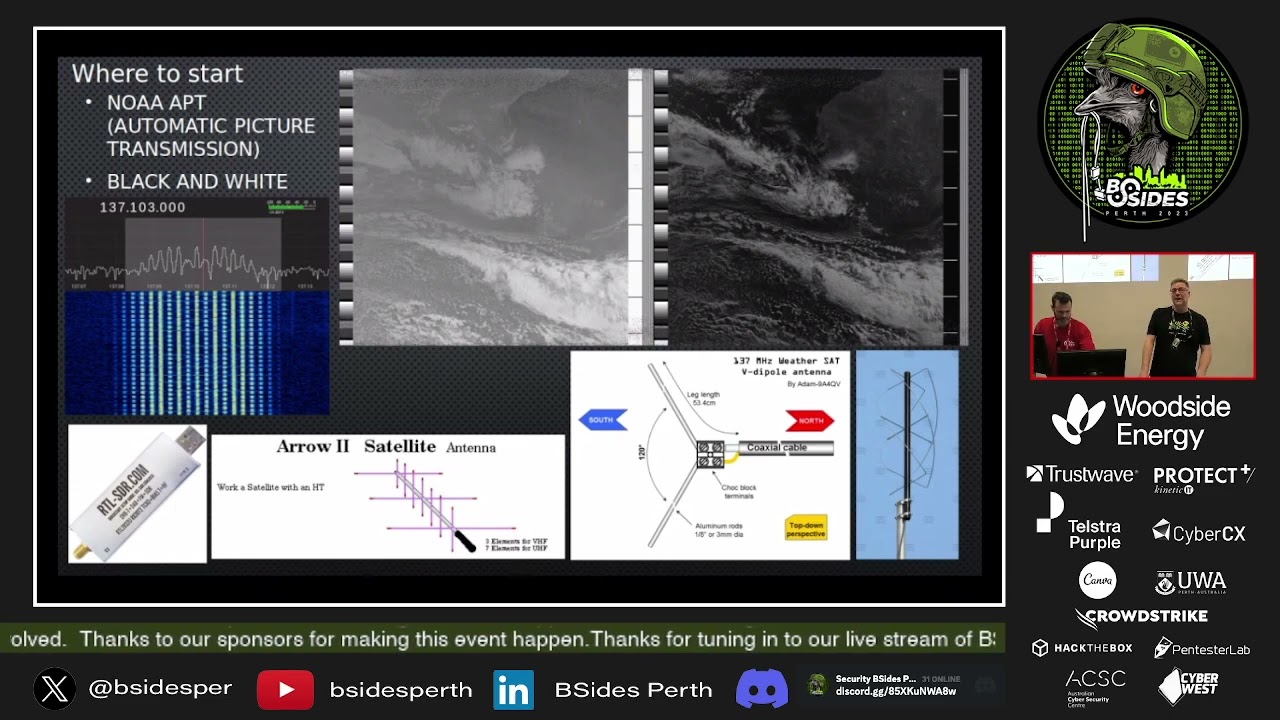
um but for the start most people start with NOAA apt um it's called apt it's uh oh sorry yeah uh it's called automatic picture transmission it's black and white as you can see from this image up here on the right hand side on the left hand side you get infrared visible band this is an analog transmission that comes down over the two meter band roughly 137 megahertz in frequency um the bandwidth's roughly 34 kilohertz wide um normally your best bet is to set a wider sample rate uh so you don't have to move and track the satellite as it's passing um because as you're as you'll realize with polar orbiting satellites um you deal with a Doppler shift as the
satellite crosses over the sky so either you can lock onto the carrier of the transmission and try to track it manually or via software or you can just open up and listen to a bit more uh of the downlink and and effectively mitigate that issue these signals are very easy to get if you had a handheld transceiver like a bow thing or a yesu or anything like that you could tune into this frequency look on software package like say Jeep predict orbitron on Android there's a program called look for set find a pass of Noah 15 18 or 19 and go outside and you'll hear these these uh signals um it sounds like a really bad sort of
like electronic dance music um but it carries quite a bit of data as I said they're very easily received and decoded uh I've used an rtlsdr uh that I've got in the corner one of these right here to do this in the past for most of the stuff when I was doing two meter reception though I was using an Air Supply mini which is a slightly better SDR so you have multiple antennas that you can use to track these uh satellites as they're passing overhead and down linking information you can use a yaggy antenna that's an aero satellite antenna there on the screen you only use the two meter band of that yaggy that's actually designed
to do ISS uh conversations with other people which is another thing that more hand radio enthusiasts do instead of software to find radio but it's an option another thing you can make is basically a v-dipole which is this image here which is nothing but gravity or antanis from an old television set you open that thing up to 120 degrees extend the elements out to the appropriate length of you know roughly 53 centimeters and you'll be able to pick up that imagery a lot of people build stations to uh basically automatically capture all of these passes and then process the imagery after the fact and qfh
a enjoy it uh um
which was the second satellite where these images came from um off on that satellite Russian satellites are interesting it's probably the sequence where I can say it they're not very reliable um they've recently launched meteor m2-3 which is also doing low rate pitcher transmission um unfortunately most people that have looked at it in the community over the past six to eight weeks or four to six weeks have realized that um most likely the uh qfh antenna that's on the satellite similar to the antenna I showed in the product screen that's what they have on board on the actual meteor satellite on a little bit to transmit um it did not fully deploy so people are
noticing weird things where about halfway through the past they're signal to noise ratio were dropped through the floor um with standard like qfh omnidirectional antennas so if you want to have a look at low rate pitcher transmission I would recommend grabbing a a three element two meter yagi or bigger her and then actually hand tracking that as it goes past that'll give you your best chance of success so on this screen I want to call out as well up in the top left there's a screenshot of a tool called sat dump um sat down is pretty much the sole tool I use to download weather satellite imagery it is developed by a bunch of European teenagers primary it seems who
are exceptionally smart people um and I am very happy that I've come across to be a software stack as you can see from the screen I'll give you a bit of a rundown so you can see how you've got a constellation there with four distinct constellations within that so that's a sign that this transmission is quadranture phase shift keying so basically it's got four constellation points in the transmission the better your Sigma to noise ratio the cleaner and more separated that constellation will become when you're receiving the imagery so RPG's fun sadly there's only one satellite that's doing it right now uh because it's in polar orbit at best you get two attempts per day one of them
will be at night and because there's so little bandwidth for the satellite in the past time uh uh effectively it always spits out a RGB jpeg so at night your image will be completely black um interesting but yeah not something that you want to spend that much time on just for the hassle of like getting out there and finding the satellite alone so moving forward Let's uh let's bump it up a notch um instead of sitting on two meter um let's go to L band so in the L band there are a lot of polar orbiting weather satellites that transmit weather imagery and other sensor data down on L band um these images are often much better in
terms of the resolution than um the low rate pitcher transmission definitely heaps better than the automated picture transmission uh or uh sorry apt of the the NOAA Birds um and as you can see here on the left obviously the satellite status uh uh spreadsheet or list is a bit out of date but all vanilla no 15 18 and 19 polar orbiting birds have hrpt transmitters a sadly has turned off now medop BNC is still on the fin young FY green series um is available for some people around the world China for whatever reason it's decided to turn off all the Royal orbiting satellites over Australia so I've never been able to get a thin young
image which is a bit disappointing but it's okay um we also have meteor in into in 2-2 and now in 2-3 that just recently launched as I mentioned um so when you're doing um l-band satellite reception you you effectively need um more gain which requires a bigger dish and a better feed to receive that and quite often a low noise amplifier as well so I'm going to step over here real quick and just show you um this is a uh oh right oh cool thank you I should have done that this is a 3D printed Helix for L band that I made um in my shed I've got a mate who has a 3D printer he can spit out these
scaffolds and next to no time it's a design from a guy named Derek SGC or at least that's what he goes online as uh on Twitter and YouTube um uh check the public guy I believe um really helpful really friendly um as you can tell this feed is a helix so it's circular polarized and and this feed is a left-hand circular polarization feed which basically means when you're holding what you're wrapping the coil against you're holding it well you're holding the what you're rapping against with your right hand and you're wrapping with your left hand hence the left hand circular polarization so that is a 1.7 gigahertz feed for l-band transmissions this is a right hand circularized feed
for best man Transmissions which is a higher frequency range roughly 2.1 to 2.3 gigahertz so as you can see we're compared to the l-band feed the s-band feed is tighter in terms of diameter of the Helix so the Helix that you wrap the diameter of that Helix as well as the spacing between the elements is all of it effectively Tunes this feed to be able to receive the satellite Transmissions I I know this like probably looks a bit complex but it's literally just a 3D printed scaffold with some copper that I wrapped by hand on a glass [Music]
so um as I said foreign [Music]
is roughly 4.2 million bits per second um these scrs only do about 3 million samples per second so it's a little bit under baked before we're doing that op but it can still be done [Music] to mentioned
laughs [Music] on the bottom right what you would probably all recognize is a foxtail dish I'd pick these things up off the side of the road when people are doing bird side collection because everybody has been throwing them out because nobody uses Foxdale satellite anymore um they work very well for l-band and s-band reception work um as you can see I've got an Air Supply mini basically just velcro to the arm of the dish I've got a soil bird connected directly to the feed that's bolted to the dish and then I just run a USB extension lead from the software-defined radio into a laptop that that is literally as simple of a setup as you
need to get up and running on these sorts of things [Music] um one thing I will mention though is that obviously hand tracking with a dish on a tripod can be challenging especially when you go up with the larger size dishes um that being said it's actually not that hard l-band is quite forgiving so just sort of wave the dish around and see and quite often you'll be able to dial it in fairly quickly so this is the current setup that I have now um for lban satellite reception um obviously you can see the dish is a little bit larger that's a 90 centimeter offset there's a crew up north of the river called scitec that does satellite
uh stuff they were certainly one of those dishes for 82 Australian dollars um they've got a pallet of them um it comes in a kit it is super cheap and it is a phenomenal dish for the money for doing l-ban stuff you can get everything with that um one thing I will call out as well uh you can see that the feed is the same one as the one I have here um the cabling from the low noise amplifier to my SDR swapped so that's what's known as LMR 400 when you're up at higher frequency ranges uh basically one gigahertz or above cabling uh losses starting to become a real issue um so if you can use LMR 400 instead of
something like RG58 you'll get effectively uh 1 DB SNR boost just from swapping that cable alone and I mean it doesn't matter how long it is I I can run three meters of LMR 400 to replace a 10 seated 10 seating 10 centimeter long piece of RG58 I still get that SNR boost um obviously if you're using a down conversion converter it's not that much of an issue but for something like this where I'm receiving it at 1.67 gigahertz it actually makes a difference and then obviously that's the laptop I've got here I've upgraded recently because I need a grunt to your laptop so because I wasn't here yesterday because I've been quite sick for the second half of this
week um I took the opportunity to go out in the driveway and get a couple of double band images for you guys to show you basically yourself yesterday when you're here at the con and then give you a bit of a compare and contrast so we'll start over here with Noah 19. um this is an avhr image on the left that's the advanced very high resolution radiometer um it's basically one square kilometer per pixel it has three visible bands two infrared bands and then you basically use that imagery to build out composite images based off of those base bands so this image on the left is called a uh let me just make sure yeah I know a
natural color corrected um these are new Composites that have only come out in sat dump recently um there's constant development going on in this space both with Composites people finding channels and new things in data um it's a fast moving space is the best way I can say it on the top right you've got what's known as the day microphysics corrected image um I say corrected because as these satellites are passing over the Earth the perimetry of the earth comes into play and so the images actually are sort of bent around the sides so you use software processing to effectively flatten that out to make it look normal and that's the reason why on either side
of the images the actual apparent resolution of the image uh degrades a bit when you've got a corrected image um are you set up as per usual with this I put this in to show you that unlike the meteor satellite you can see that this only has two points in the constellation that's because NOAA transmits binary phase shift team instead of quadranture there's no Forward Air correction on these Transmissions [Music] um they're great but at the same time they could be better if it was quadranture if if there was error correction enabled um that sort of thing and and you can see there I I had a good signal to noise ratio roughly 16 DB on that pass
um but also at the top of the image you can see where I didn't have proper sync before it finally clicked in and then also in the day physics image you can see the line through there which is basically right where I didn't have good alignment and I lost some data so Noah 19 no error 18 Noah 15 they all have the adhr imager on them they are degrading because they're a bit old um and I wanted to do lower 19 as well because this is the same satellite from the first image of the presentation that fell over um they spent a lot of money to repair it and then launched it and it's still
in use today but yeah it just goes to show that even if you drop a satellite have to spend hundreds of millions of dollars you can still get it back in in workable condition and variously this is a meta B uh ahrpt image this is the exact same imager the AVH RR imager that the NOAA Fleet uses the Noah pose Fleet um granted it is a slightly newer uh image imager um that being said it has feck it's a quadrature phase shift keying transmission so you get a lot less noise from the image you get a lot more error correction if I zoomed in on the image I wouldn't have individual dots where I just had white pixels where
where I I I missed a bit of data um they're very uh very good I I like out of all the Alabama polar Birds I find metop the easiest to receive and it produces the best pictures in my opinion it also has more instruments so up in the top right you have what's known as an Iasi image um that doesn't look like much to me it's definitely not as pretty as the color Composites um but apparently this one instrument has effectively doubled the numeric weather prediction capability of humans um they're arguably 50 to 60 percent of the reason why we now have 10 day weather forecasts instead of seven-day weather forecasts so this one this one instrument measures temperature
and humidity in the atmosphere at one kilometer uh bands so it allows when you take all that data along with all the other weather data that meteorologists have when they Plumb that into very big computers this is what allows us to give like proper weather predictions for a longer period of time and I think one of the things that I find really curious about it is is they didn't know when they launched these instruments just how impactful it would be until they started crunching the data um so it it just it's one of those things where from from my perspective um yeah these these Technologies are still um advancing and they're still learning new things about uh the weather and that
sort of stuff so um yeah we're really um very strong Transmissions with meta I do the sampling at six million samples per second because as I showed an earlier Slide the Transmissions roughly 4.2 megabit per second um but yeah it's it's a wonderful satellite both met up B and C so moving past that well let's say we don't want to look at polar orbiting satellites anymore let's go up to geostationary satellites um so geostatially is interesting because you you can easily receive full disk imagery of the entire planet from the perspective of that geostationary weather satellite um the downside is is they're roughly 36 000 kilometers away from us in geostationary orbit the upside is is
they don't move because they're geostationary so you just align your dish and get it all nice and dialed in men here don't care off you go you know it's it's great stuff so um originally obviously I started with polar orbiting satellites I've shifted over to geostationary um quite heavily just because of the data and the Simplicity um in this image up here on the top left this is from usradioguy.com this is a scale image with oath and all the polar orbiting satellite stuff basically smashed on right at the very left hand side of that image in front of the earth so that's where all the satellites from the previous imagery I was showing are all located roughly on
the right hand side is geostationary orbit and then in the middle is basically GPS so you can kind of tell that that's a true to scale distance image um how far away these things are but like I said they're um they're not moving from the parent perspective of us on the ground so they're very easy to Target with an appropriate dish on the bottom right you can see I've got a foxtail dish on a tripod I found on the side of the road um and uh an old think bath pad laptop and this was me successfully receiving what's known as gk2a Geo Comsat 2A which is a South Korean Geo stationery weather satellite so popping
over here this is what you can expect to get from gk2a it's got a transmission called low rate information transmission or lrit um it's roughly 64 kilobits per kilobits per spec kilobits per second binary phase shift keying um every 10 minutes you get a single IR 105 image um infrared image but because you get them every 10 minutes you can make very um very detailed gifts out of those images because you get 144 of them per day um but not only can you you know process them in that way to make animations of the planet you can then post process the images so on the left hand side this is a tool known as Sanchez which is used to
false color images it's the same color palette that people use for the APT Transmissions from NOAA to color false colorize those images if they want to on the right hand we have an image that's gone through IR enhancement process so you can actually run a python script over the the images that come out from from the satellite and it will effectively use IR enhancements to show you uh weather strength in in real time off that image so moving forward from that you can then take that stuff and obviously animate it again um so gk2a is neat I I like it but um from my perspective it's probably the most useful scientific geostationary satellite we can see here in in
Australia but at the same time it's the most underwhelming because it's only infrared so moving past that I'd like to show you Electro L3 lrit so Electro L3 is a Russian geostationary weather satellite it sits roughly 30 degrees elevation from us uh over the equator roughly south of the tip of India so I can just see this satellite from my backyard with a 85 centimeter offset it transmits every three hours except for in the middle of the day when it would transmit a fully illuminated full disk image I don't know why the Russians turn it off for that time slot I don't it it just yeah it's frustrating um it would be a lot better if they gave
you a full disk image especially when they commission the things they always drop one or two out just to show everybody it can be done and then promptly don't transmit for that session um so it does three visible bands and then two infrared bands so you get basically a channels one two three and then Infrareds channels nine and ten every three hours um so what I've done is taken some natural color Composites which come from the three visible images and you can see the progression from a single day from the start to the end of the day from our perspective from the satellite and then the infrared 9 and 10 10 images um I I've
I've had a station running on Electro L3 since roughly April of 2022 I consume these images daily uh I like them a lot even though as you can see especially like say in that second image the Composites that come down from the satellite are uh all well they're converted into jpeg as are the original bands that are transmitted um it they are Overexposed images so where uh parts of the earth that are highly illuminated you'll get washed out imagery but still it's color uh it's it's natural color Composites I I enjoy Electro satellite images um moving past that there's also a Chinese geostationary satellite Network called fin young 2. these are images from thing young 2G uh
this is not low rate information transmission this is a bucket load of data a single fully illuminated false color image like that that's a crop by the way because when I tried to put the real image in my presentation it crashed my presentation software they're roughly 90 megabyte images this satellite transmits hourly at the top of the hour it does include here and then multiple infrared bands and also a water vapor band um so not only does it do hourly Transmissions it also does four times a day a half hourly transmission as well I'm not sure the reasoning for that other than maybe they wanted to get the fully illuminated full disk image of the
planet daily because it does happen to coincide with one of the fully illuminated time slots um but yeah this is uh a really interesting uh satellite it's a linear transmitter which most geostationary satellites bar the electro uh satellite I showed on the last slide which is a circular polarized transmission you're better off using helical or sorry uh linear um feeds and and Prime dishes to receive these types of signals so now that I've shown you this I want to quickly go to the next slide which is a screen recording of sat dump as being young 2G is just starting up to transmit at the top of the hour time slot the reason why I wanted to show you this is
because I've shown you screenshots of sat dump but I haven't actually shown you any video of what it looks like this satellite is spin stabilized at a hundred revolutions per minute um so if I had to guess I would think that's the reason why the signal looks the way it does but to be honest with you even I don't know so this is basically what it does at the start of the transmission um this is probably a minute or so before uh it starts actually transmitting the imagery so you can see down on the binary phase shifting demodulator on the left hand side it's having a bit of a drama because it's like I don't know what's going on here
I've got a massive carrier Spike up top I've got good SNR but the constellation isn't locking right on the bottom hand side you've got your image progress as the image is decrypting or sorry as the image is receiving this is what's known as live processing when when I look at satellites if you have a computer that's grunty enough to handle it turning on live processing helps a lot at least for me primarily because on the bottom left the average SNR and the SNR figures help you align things immensely if you're just looking at the signal from the waterfall in the fft above and trying to ascertain what's going on and there we go uh my my converted video
dies there but basically you can see just there that's when it was just starting to spin up and and transmitting the image um so moving forward from thing young two we now have fy4 uh fy4a and FY 4B are on orbit now they're Chinese geostationary weather satellites as well um when FY 4A started up I got really excited because it was going to be another uh low rate information transmission or lrit bird hourly Transmissions full disk imagery I was like oh sweet you know like I'm going to have something else to point out and some some new data to start collecting um it's abysmal it's the best way I can say that that image on the left is like
4-bit resolution um you zoom into that it is just woefully inadequate for anything it's the worst geostationary data I've ever received and it is the newest geostationary satellite uh constellation that I point at I don't know what's going on with China um but yeah it's it's confusing to me they also do a vapor band and then an infrared band lost a bit of the last uh lines of that Vapor band transmission this thing's a little bit hard to receive if you're not using linear feeds and linear dishes going past that I know I said Being Young 4A was bad well let's have a look at ping Yun 4B um on the top right is a fingyan 4B
transmission with the stereotypical lrit hump that you would expect to see on the left is fin young 4A where I'm successfully live decoding as it's transmitting one of the things you'll notice between left and right is on the right you have all that other transmission on the background what that is is the original satellite I showed you gk2a that's its heart rate information transmission signal um you're probably thinking well that's a bit of a problem because you don't really want one satellite's transmission behind another satellite's transmission at the same time if you want to decode either one of them successfully um so this is a headache I I don't know why they chose to basically set their low rate information
transmission frequency to stomp on an already established frequency for a satellite that effectively sits beside it in Geo orbit and yet here we are um so the last time I had looked at that when it was still doing the normal Transmissions they dropped the power rate down for the lrit transmitter I assume to try to sort of help with this issue um but recently the um the Chinese Meteorological association or whatever they're called technically have moved into uh what's known as intensified operations with fy4b uh I happen to have a look at it and these bottom two images are Transmissions from that intensified operation um that that's not lrit that's binary phase shift keying um it's massively wider than what it
would normally transmit across as you can see from this image versus this image and you can see the uh gk2a transmission on the background on the top and bottom of each one of these um I have no idea what China is doing with the fy4 constellation I'm going to try to have a look at their High rate information transmission which is uh more channels better imagery than the lrit that they do I'm probably a week or so from looking at that I've just got to build myself a linear camp antenna feed but yeah so you can look at things and find weird things in space and then you talk to people on Twitter and they're like yeah
I'm seeing this weird stuff too and this website says this um it's it's a really interesting sort of space to be in right now so moving on stations um I'm currently running three stations on the left is gk2a on the right of that is my Electro L3 station and then an FY 2G station um these things run 24 7 in my backyard I'm consuming a lot of data at the moment I've got roughly half a terabyte of geostationary satellite imagery so far and because I'm sitting on gk2a I've only been listening or sorry FY 2G I've only been listening to that satellite since sort of late January I've probably got 400 gig of data from it alone
because of just how large the the images are and how often it transmits so moving forward board um where do we go from here well we need bigger dishes we need more power we need we need to get better better images right so I found this dish off Gumtree from a guy north of the river for 120 he threw the base in for me for an extra ten dollars um it's a 1.2 meter offset uh it's phenomenal for doing uh bigger things be it l-band s-band or even x-band um so moving forward I've been able to use that dish to get Electro L3 hrit which is similar to the lrit transmission I was speaking to earlier
this starts at the 12th of the hour instead of the 42nd uh the hour every three hours it does um channels one through ten from the electro satellite so the only thing that I could do better from an electro geostationary satellite perspective is if I started pulling down the roll x-band downlink data as opposed to this High rate Nation transmission as you can see the in sat dump it looks quite a bit different in terms of the transmission that's how hrit looks you don't need that much SNR to to actually get locked into code I had a little over four there and that worked great um and then yeah so that's a visible band natural color composite and then
some of the other um uh uh different bands that you get be the infrared or water vapor um moving on from there stepping up to s-band so s-band is similar to L band but obviously it's higher in frequency so roughly 2.1 or um yeah uh 2.1 to 2.3 gigahertz um obviously that's starting to get very close to 2.4 gigahertz Wi-Fi which is an absolute nightmare for RF interference perspective so my setup for this is a little bit different same foxtel dish smaller feed I've got a mini circuits LNA which cost more but is better and it's an s-band capable LNA and then I have what's known as a cavity filter so that cavity filter basically filters out
everything bar the s-band signals that I'm actually looking for so it's got a hard cut off at 2300 anything above that in Wi-Fi it just completely filters out so when it comes to s-van top right NOAA all the three NOAA satellites are now doing s-band hrpt just like they do on L band so that's an example of that on the bottom right this is Coriolis that's a United States Department of Defense weather satellite to do wind measurements for the United States Navy so apparently if you're in the U.S Navy on a boat you point at this satellite and it tells you how windy things are going to be around you and everywhere else it's been up for a long time it was a
technological demonstrator it's unencrypted I'm not going to go to jail for looking at that at um but yeah it's reasonably interesting that being said there's not much weather imagery on s-band in general um so whilst it's good to have the capability to look at s-band um from a pretty picture perspective it's it's not the greatest place to be so um just wanted to show a few favorite pictures that I've been able to get over time um so this is an electro L3 natural color composite from the April the 20th 2023 solar eclipse that happened here in Australia so the satellite took this photo at 11 30 a.m which uh was when exmouth was in totality for roughly one
to two minutes so it was just a weird Stroke of Luck that the satellite took the photo at the exact same time that we were under a solar eclipse so it took the photo at 11 30 transmitted it down at 11 42 always worked from home that day so about seven eight minutes later after that transmission finished I immediately dumped out and you know decoded the imagery because I wanted to look at the eclipse so I thought that was pretty interesting stain right here this is a met up B ahrpt image that is 4028 lines in total length um I got this image from taking that dish I showed earlier the 90 centimeter offset putting it in the back of my car
and driving up to the locals my son's school oval um I live in the hills on the side of the Hill surrounded by trees I do not have good line of sight from Horizon to Horizon to do polar observations so you can take your stuff on the road um it's a hassle it's a headache but you learn new things like you know pick things down when the wind's blowing because the wind never blows on your property but if you're out on the the coastline and trying to do a demonstration for a bunch of school students you'll break your feed and disappoint everyone um don't do that um but yeah so if you were in a clear
location with like clear line of sight to either side of the Horizon you can get near 5000 lines from an image it's not unreasonable to expect for for us to be able to see Indonesia from these satellite uh images as they pass by um so moving forward expand um I I've been on Alabama for a while I've done a bit of s-band I'm now probably days away from starting to test on x-band um x-band is expensive um there's a lot to do there um all of the satellites that I've basically shown you thus far have down links for the well except for the NOAA pose but have x-band down links where you can get raw data from the satellite
um the x-band Transmissions will not be usable for something like a hack RF unless you're doing awkward or maybe Terra everything else is going to be 30 to 50 million samples per second or more base requirement so I bought a blade RF micro it's got an fpga on board it's stupidly expensive if anybody wants to do some 3G 4G testing yeah we can use that um but yeah it's a very expensive SDR but it's very good because it can do up to 60 million samples per second they just released a firmware in February to where you can go from 12-bit to 8-bit and unlock 122 million samples per second um it Sky's a bit of the limit x-band
sits at around the high sevens to maybe 8.4 gigahertz in frequency range the the SDR that I bought only goes up to six gigahertz so I need a down converter so basically what that thing does is take takes x-band signals and then downshifts them to a lower frequency that I can then tune in with my SDR to receive so it's not as expensive as the blade RF that costs 540 US Dollars um but a couple hundred Euro minimum and you know I bought it from a guy off Twitter um on the bottom right is a mid-tech uh low noise amplifier uh for x-band I got lucky with this I found it on eBay it was second hand they had only shipped to
the states luckily I have a workaround with that given my accent um so I bought that thing so I have all the hardware in hand I've got connectors on the way that are low loss connectors um x-band looks to be fun it's a lot more challenging as well hand tracking with that 1.2 centimeter or 1.2 meter offset I showed earlier for a satellite in polar orbit is going to be hard x-band is even harder in terms of like your um margin for error for the for the tracking it's going to be a nightmare and I'm very much looking forward to it um so that being said that's pretty much it for my presentation um but I'd like to open up to the
questions I know this stuff is not um very prevalent so if anybody wants to ask anything I'd love to hear it yes please oh thank you
yes
uh-huh yes
no that's a very good question um what I what I'm doing is all uh non-pii uh I I showed you the poxag pager stuff earlier um yeah don't re-transmit that um it's sort of accepted in most circles that if you're just listening and and not using the information you're probably not going to get into trouble because how is anybody going to know all these sdrs foreign all these sdrs bar this hack RF or receive only the heck RF has a very very low transmit capabilities so you're you're not going to run into issues with like basically stalking on somebody else's license spectrum and having an enactment engineer come on site and threaten you with ten thousand dollar
fines um yeah they do that um but but yeah uh all of the satellite stuff that I'm doing it's all designed to be publicly consumable um by anyone in the world um the only satellite I showed that has any encryption whatsoever is actually the gk2a satellite um and the the South Korean meteorological organization publishes the decryption key on their website in a sort of here's a software package of how to look at our images um and so the the way set up does it because they were a little bit concerned about pre-baking that decryption key into the software because they thought oh this might actually be a little bit of a legal Gray area when you boot up and
start listening to GK gk2a you need an internet connection because your laptop will actually go out and fetch it from the website and then load it for you automatically so um I I agree with you especially with some of the more local things that we can listen to Just because you can do it definitely does not mean it's legal um and and you can definitely run into um pretty severe headaches if if you start taking stuff like that and plumbing it out into the outside world no no because you're not transmitting basically when you're doing amateur radio stuff primarily the the license is all around you transmitting on on licensed Spectrum so this is why when
you have a ham radio license the the the the um the restrictions around your license are based around what bands you can access and transmit on and what wattage that you can transmit across those bands so um because I'm not doing any transmission I'm only doing reception it's fine um I don't want to transmit to a satellite is probably what I can say as well I'm very much happy to just listen and observe um yeah yes sir is there any Header information or beacons come from a satellite tapes heaps yeah so um uh most of of the uh satellites well basically all the Transmissions have preambles they have sync codes everything is different um and so like by understanding that
stuff you can actually sort of reverse engineer the signals um I've only started playing with stuff like that there's a tool called Hobbits where I can basically take the the tattoo files I get from satellites Plumb that into Hobbits and I can look at the bitstream I can see like Electro Transmissions from multiple time slots that sort of thing um I I just see boxes at the moment though in patterns um there there are people that can look at this stuff and tell you hey like that's uh unencrypted and like yeah we should look at that it's just magic to me but yeah someday hopefully uh do you mind do we have time for a
couple more uh yes sir yes
um to get a uh Rotator that has the strength to hold the dishes I use and the resolution necessary to track satellites um especially on x-band um your your Mount is going to run four figures minimum not including shipping nobody makes them here um so like I've looked into doing that that's a very long down the track project a lot of people make them manually spend a lot of time on them with encoders and things of that nature but for right now I think I'm just going to stick to hand tracking because I just don't have the money it's already expensive enough just buying all the uh other stuff without like going into a rotator
look I I've got a couple of telescope mounts I've thought about using one of them for a satellite I've got an equatorial Mount um it by by software it is capable of being used with like G predictor orbitron to slew the telescope Mount um automatically but uh I I've not gone down that path yet Ben you had a question yes some stereography it's got a fair playing the rise of accessible SEO has kind of kept alive the kind of analog the processing side of the CTS that said all these space agencies seeing the capability of the Volkswagen Supply well um yeah that like my shirt this is the hack usat you know competition that they do yearly
um this year I believe was the first year where like the finalists of the hackers.com at Defcon I believe it was Defcon or black hat one um they actually got the ability to try to hack this satellite on orbit in real time um so I believe it was a cubesat but basically like yeah there were I think maybe five teams like who had access to the hardware and everything else and um got given the kid how to jail free card to start transmitting to a satellite in real time to try to I assume make it do things change its own orbit parameters that sort of stuff um and uh DOD is starting to realize that like listening to the hacker
Community about all of the signals that they just blast across the the world on a regular basis might help them in the long run um so I think they're trying to sort of Rectify that now and build a sort of more um less adversarial uh uh relationship yeah no worries thank you sir um just what oh yeah from the top of one more one more go ahead sir okay so um for all the l-band stuff that I do basically max resolution is one square kilometer per pixel per visible per band right um some are a little bit less resolution some are slightly higher resolution like the I believe the thing young visible imagery is probably 0.8 I think off the
top of my head um that being said x-band um with some of the satellites up there you get 250 meters per pixel resolution um I was looking at some imagery from Aqua from a couple days ago from uh southern Europe um and it's like you're sitting there looking at Sicily there's Mount Aetna you can see the smoke coming out of it um the the the the level of like um apparent um uh resolution you can get from x-band is really quite phenomenal and that's the reason why I want to go there and that's the reason why the Transmissions are such a high or such a large sample width um because there's so much data that they're dumping down which is also
why they're on X because there's not enough bandwidth and L or S bands to handle a you know a 50 million sample per second transmission yeah okay cool thanks again forgive me
Related talks
 9:14:20
 7:10:54
 31:32
31:32 33:04
33:04 10:10:50
 41:24
41:24